
Just before we jump into 2022, I was looking to visit and discover a new mountain of Greece, that I had never visited before. In the meantime, it was also important to check the weather forecast and where there would be enough snow for a winter mountaineering ascent. Greece, is a very mountainous country and therefore there is plenty of choice, but for this time, I have decided to visit mount Panaitoliko (or Panetoliko).

About Panaitoliko
Panaitoliko is a mountain range in the northeastern part of Aetolia-Acarnania and southwestern Evrytania, in western Greece. Its highest summit, Katelanos, is the highest point of Aetolia-Acarnania at 1,924 m. Its length is approximately 25 km long from east to west and its width is approximately 15 km wide. The nearest mountains are Kaliakouda to the northeast, the mountains of Nafpaktia to the southeast and Valtou to the northwest. Lake Trichonida lies to the south. The Panaitoliko extends from the Acheloos valley in the northwest to the Evinos valley in the east. There are forests in the lower areas, and grasslands in the higher elevations.
It is the natural border between the prefectures of Etoloakarnania and Evrytania. Panaitoliko (Panetoliko) is the last part of southern Pindos. Its peak is located in Etoloakarnania and it is the highest mountain of the prefecture. The foothills are covered with cedars and up to the 1700 meters there are also pine trees. Its highest part is covered with alpine vegetation.
10 Peaks of Panaitoliko
Some of the highest peaks of Panaitoliko (Panetoliko) are the following:
- Katelanos 1.924 m.
- Yorla 1.820 m.
- Triantafillia 1.817 m.
- Krimnitsa 1.816 m.
- Xanthi 1.810 m.
- Koutoupas 1.795 m.
- Neraidovouni 1.781 m.
- Platani 1.777 m.
- Katavothra 1.752 m.
- Koukoureki 1. 746 m.
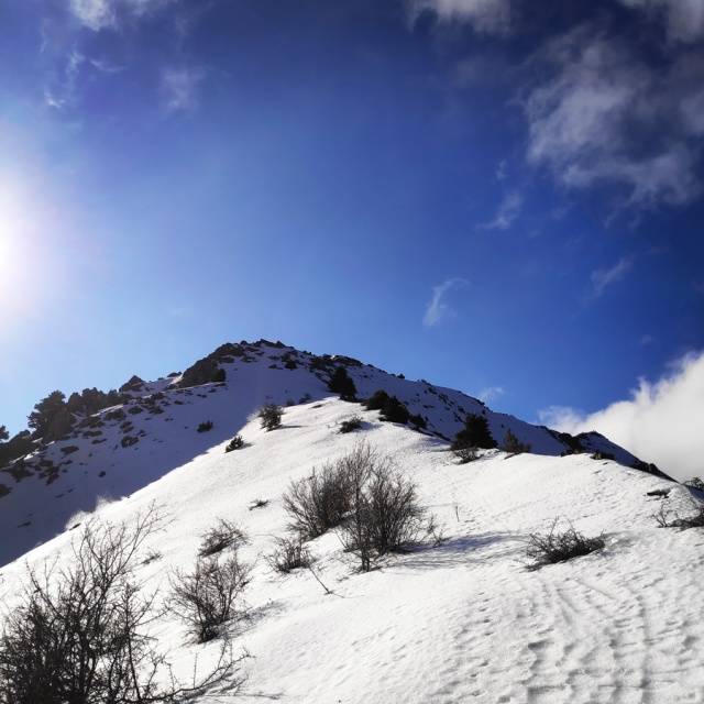
Paliochori – Krimnitsa pre-Peak
Panaitoliko, is a large mountain and offers various routes in order to reach the highest peak, Katelanos (1.924 m.) or the other peaks of the mountain. Our initial plan was to start from Kato Labiri and via Kastanorema to reach Katelanos peak. This is supposed to be one of the nicest routes of Panaitoliko. Though, as soon we reached Kato Labiri, I have noticed that the Kastanorema creek was full of water and it would be very difficult if not impossible to cross it twice during the hike. Therefore, I have decided to change the plan and instead of hiking by the banks of Kastanorema, to start our hike from Paliochori and via Agios Athanasios to hike towards Krimnitsa Peak.
Prior of visiting a mountain, it is always very important to study the various routes, the various peaks and and all alternative trails, because many times we need to change our plans based on the conditions we find on the mountains. This is what I have also done prior of visiting Panaitoliko and the time I have spent to study the various routes, payed off with this last minute change of course.
The hike starts from Paliochori and passes next to a fence of a house with north-west direction towards Agios Athanasios chapel. Within 10 minutes we reach the chapel with great views towards the various surrounding peaks. Upon that, we enter a trail that is also used as a dirt road and we hike for few kilometres up to the point we reach the saddle and the end of this trail/road. The hike up to that point is very easy and pretty much everyone can do it.


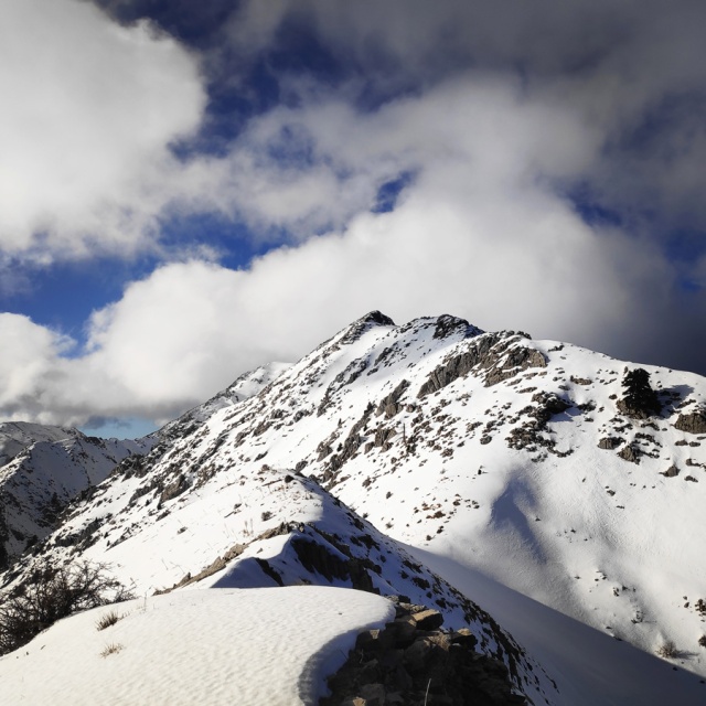
As soon we reached the end of the trail, we had a short break for a snack and some water. In addition, due to the fact on this trip a climbing buddy without prior experience in winter mountaineering joined me, at that point, we spent some time training on how to properly use an ice axe and crampons.
My climbing buddy adapted rather fast the basic winter mountaineering techniques and upon that we started the ascent on the icy ridge. Prior of reaching the ridgeline, we needed to cross an icy traverse and my climbing buddy did great.
On the ridgeline we spotted some footprints from a fox and those lead us to the pre-Peak of Krimnitsa.


Details of the hike:
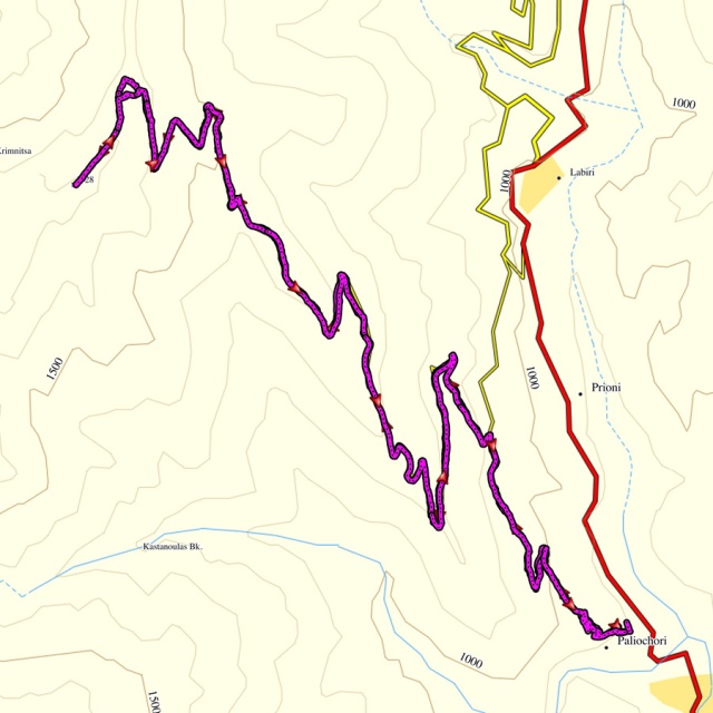
- Location: Panaitoliko Mountain
- Starting Point: Paliochori
- Ending Point: Krimnitsa pre-Peak.
- Trail Signs: partly signed path (when there is no snow)
- Minimum Elevation: 865 m
- Maximum Elevation: 1.728 m.
- Total Distance: 12,7 km
- Difficulty: Easy
- Water Features: No
Bellow you can see the route we have followed on a map and on 3D:
Where to stay
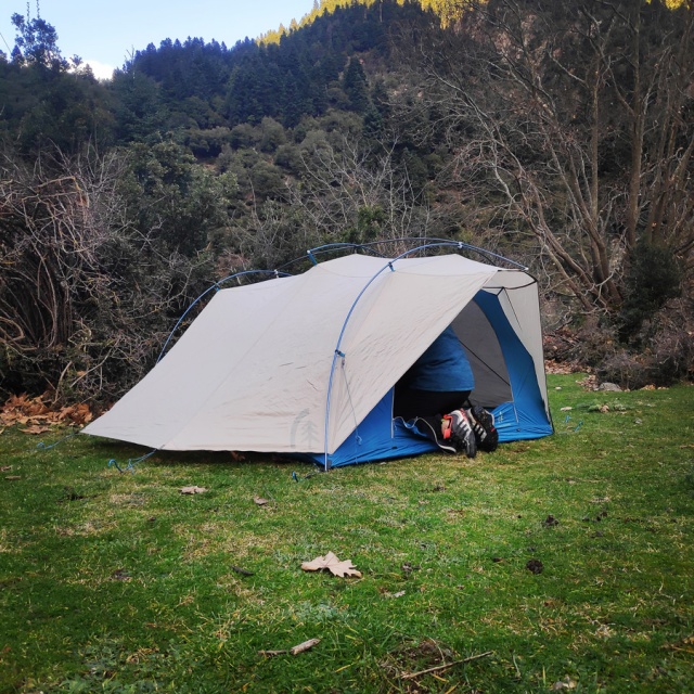
During winter time, the villages of Kato Labiri, Labiri and Paliochori seem almost deserted. There are a couple of B&Bs, but I guess are operating only during the summer months. Therefore, we had arranged to have a tent with us and we set up our camp on this location.
Panaitoliko Mountain Hut
Alternatively, should you wish to start your hike from the village of Peristeri, you can stay on the mountain hut which is located here.
Gear & Equipment
For this trip, I was carrying the following main gear:
- The North Face Verto 27 Backpack
- Mammut Wallrider Helmet
- Petzl Altitude Harness
- Garmin Dakota 20 GPS device
- Quechua Tech-Fresh 50 T-shirt
- Cumulus Incredilite Endurance jacket
- The North Face Verbera hiking boots
- Petzl Quark Ice Axe
- Rock Empire Mackki crampon
- Sierra Designs Flash 3 tent
- Cumulus Panyam 600 Sleeping Bag
- Klymit Static V Sleeping pad
Additional Information
Should you wish more info about Panaitoliko and the various routes on this mountain, you can visit this blog (in Greek).
Below: This map marks all the mountaineering adventures that have been featured on Olympus Mountaineering so far, including several Sport climbing crags – Select full screen to expand, zoom in for more detail, or click on a marker for a link to the post.

Wow… Beautiful!!
LikeLiked by 1 person
I love your summit marker. We pile stones to make a cairn, but Europe goes all out with man made structures. I like it!
I agree with needing to know your mountain well, including all possible routes. Good for you for being adaptable and making changes at the last minute.
LikeLiked by 1 person
Pretty much in all major peaks in Greece you can find the summit marker (column).
It’s always great to see the summit column during the final summit push. 🙂
LikeLiked by 1 person
Nice to see mountains in snow, such a pretty winter blanket, well done!
LikeLiked by 1 person
Thank you for your comment and I fully agree with the pretty winter blanket. 🙂
LikeLike
Pingback: Hiking in Mikro Panta Vrechi gorge – Evrytania (family friendly) – Olympus Mountaineering
Pingback: Hiking the Black Cave (Mavri Spilia) Gorge – Proussos Evrytania (family friendly) – Olympus Mountaineering