
Tymfi is a mountain in the northern Pindus mountain range, northwestern Greece. It is part of the regional unit of Ioannina and lies in the region of Zagori, just a few metres south of the 40° parallel. Tymfi forms a massif with its highest peak, Gamila, at 2,497 m (8,192 ft), being the sixth highest in Greece.
The massif of Tymfi includes in its southern part the Vikos Gorge, while they both form part of the Vikos–Aoös National Park which accepts over 100,000 visitors per year. The former municipality of the same name owed its name to the mountain. It also gave its name to the ancient land known as Tymphaea and to the Tymphaeans, one of the tribes in Ancient Epirus.
Most part of the mountain, with the exception of its southernmost part around the peak of Astraka, forms part of the Vikos–Aoös National Park. The park is a designated protected area and visitors should be aware of the limitations to activities imposed by the law. The World Wide Fund for Nature (WWF) runs an information centre in the village of Papingo.
The simplest and most commonly used route of ascent is the one beginning at the village of Mikro Papingo, located at the western side of the mountain at an altitude of 980 m (3,215 ft). The trail that leads to the Astraka mountain hut, is approximately 6 km long. It is part of the Greek national trail O3 and is generally well marked with signs (red diamond on white) and red dots and arrows on rocks and tree trunks. From the hut, the hikers might either head northeast to the drakolimni alpine lake for another 2.8 km or southeast to reach Gamila peak, which is the highest peak of the mountain at 2,497 m (8,192 ft) for another 6 km. In both cases there are no signposts and the hikers should solely rely on red dots marked on rocks or scarce small signs attached to wooden poles. The hike from Papingo to the hut lasts between 2–3 hours and the round-trip from the hut to drakolimni another 2 hours.
The mountain is also accessible from other surrounding villages but the trails are longer and the terrain rougher and steeper. Therefore they are suggested for more experienced hikers. From the village of Vrysochori at the eastern side of the mountain, a trail of 12.8 km leads to Gamila peak through the Karteros Pass. From the village of Vradeto to the south of the mountain the trail to the peak is approximately 14.9 km. Trails that lead to the mountain can also be followed from Konitsa and Tsepelovo. Those routes are poorly and scarcely marked, mostly by dots of red paint on rocks, and are in some cases unclear and covered by vegetation.
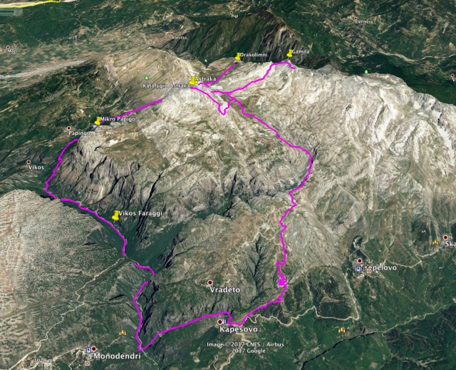
On this expedition we are going to cover a distance of total 58 km. Our starting point will be the small village name Kapesovo and through Mezaria Gorge, we will reach the worldwide famous Vikos Gorge. Following the O3 path, we will reach Mikro Papingo and from there we will move towards the high peaks of Tymfi such as Astraka, Gamila I, Gamila II, Stoma and of course the alpine lake, named “Dragon Lake”
This distance will be covered in 4 to 5 days and almost every night we will be setting up our camp above the tree line and around 2.000 meters above sea level.
The routes we are going to follow is the following one:

For this trip, I have created a list with all the items I plan to carry on me. Of course, last minute changes might take place in case weather conditions will change dramatically. This list include Item Name, Weight x Item, Total Weight and Remarks. The estimated total weight will be about 13 kg (including food and water supplies). I might try to adjust some items and reduce the weight by a kilogram, but more than that I am afraid I will not be able.
Bellow an image with the Complete list I have created for the upcoming trip to Mount Tymfi Summer expedition.


I just came from Papingo and I can say that I’m in love with Gamila mountain! 2 of our friends climbed the Astraka peak, went to Drakolimni and back in 6 hours. I am super jealous but also aware of my limits; I am just the average person and not superman like them 😀 Still, Gamila rocks!!
LikeLike
Indeed, the whole Tymfi mountain and the surroundings is a wonderful place!
Gamila I, Gamila II, Astraka and Stoma peaks are all very nice.
Also the Dragon Lake (Drakolimni), loutsa robuzi and of course Vikos Gorge are stunning too!
Well done for you and for your friends and wish you the best for the next mountain climb.
LikeLiked by 1 person
Thank you and happy mountaineering to you too )
LikeLike
Pingback: Mount Tymfi (Pindos) Thru-Hike Part 1 – Kapesovo – Mezaria Gorge – Vikos Canyon – Mikro Papingo – Olympus Mountaineering